ride
Fixie Dave's First Annual Birthday Adventure
Three bikes, a shuttle to nearly 12,000 feet, and a loose collection of old Pikes Peak trails leading back to Cascade.
- Date
- 2026-08-03
- Region
- Colorado
- Country
- USA
- Distance
- 14.5 mi
- Elevation gain
- 1013 ft
- Elevation range
- 7836–11819 ft
- Technical difficulty
- Advanced
Fixie Dave lives in Cascade, near the base of Pikes Peak. For his birthday, he proposed that we load three completely different mountain bikes into the Armada, drive nearly 4,000 vertical feet above his house, and see whether a loose collection of old trails would eventually return us to it.
This became Fixie Dave's First Annual Birthday Adventure, a name that implies an established tradition despite there having been no previous annual editions. Adding "First Annual" also creates an obligation for next year, which is Dave's problem for now.
I brought the single-speed Karate Monkey with 140 millimeters of suspension. Dave brought his rigid Jones fat bike, because apparently the terrain needed to become more educational. Drew made the defensible choice and brought a full-suspension bike with gears.
We loaded all three into the Armada, our poor man's Toyota Land Cruiser, and drove up Pikes Peak Highway to the Elk Park trailhead at nearly 11,800 feet.
From there, the basic plan was to ride to Dave's house.
The details were less basic.
The Route
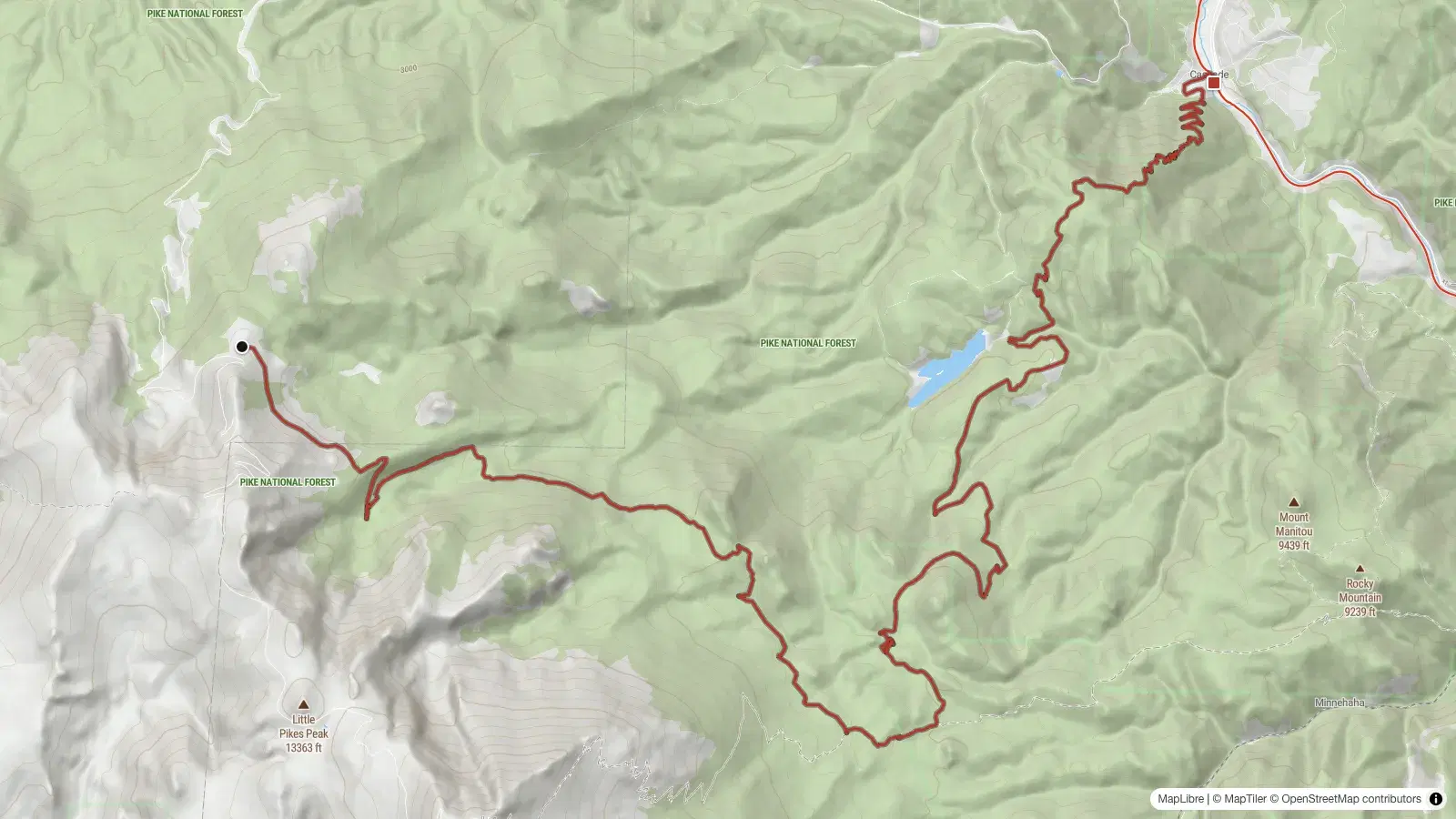
The line we followed connected Elk Park Trail with Barr Trail, the Mountain View and Cabin Creek connection, Manitou Reservoir Trail, French Creek, and finally Heizer Trail into Cascade.
According to the Garmin GPX, the day came out to approximately:
- 14.48 miles
- 1,500 feet of climbing
- 5,500 feet of descending
- 11,816 feet at the start
- 7,836 feet at the finish
- 4 hours and 58 minutes elapsed
The elevation profile makes it look like a mostly downhill ride because, in the broadest mathematical sense, it was.
We began high and finished low.
The trail had additional opinions.
There were enough climbs, rolling sections, awkward transitions, slow route-finding, and technical interruptions that the ride never felt like a five-hour descent. Gravity was generally working in our favor, but it was not working alone.
The route shares much of its line with a mapped ride called Elkabin. That version eventually climbs Heizer, escapes onto Forest Road 330, and returns toward Pikes Peak Highway. We skipped the escape and continued down Heizer into Cascade, because the entire point was to end where Dave lives.
This added a substantial final descent filled with loose switchbacks.
It also made the route much more useful as a birthday decision and less useful as a normal recommendation.
Starting Near 12,000 Feet
Elk Park begins just below 12,000 feet, where the air is thinner, the terrain is exposed, and everyone gets several minutes to wonder whether breakfast was adequate.
The opening section drops away from Pikes Peak Highway almost immediately. It begins in high alpine terrain and works downward through loose rock, embedded features, exposed sections, and repeated drops that arrive with very little administrative delay between them.
There were one-foot drops, two-foot drops, and enough additional drops that counting them stopped providing useful information. None was individually extraordinary, but they kept arriving. The trail seemed committed to the idea that suspension should remain occupied.
I used all 140 millimeters of my fork.
Dave rode the same terrain rigid.
There is no prize for this, which is unfortunate because he had clearly selected his bicycle as though one might be awarded.
The Jones fat bike provided plenty of tire, but the front end remained attached directly to Dave in the traditional manner. I could feel the fork working through repeated rocks and landings while Dave absorbed the same terrain with his arms, judgment, and whatever structural reinforcement years of fixed-gear riding have added to his body.
Drew's full-suspension bike was the least conceptually interesting of the three and probably the most appropriate. Sometimes technology exists because the problem has already been identified.
Downhill Does Not Mean Easy
The first several miles lose a considerable amount of elevation, but this was not smooth bike-park descending.
The trail was narrow in places and ran along the side of the mountain with enough exposure to keep attention focused. There were sections where the useful riding line occupied most of the available trail and the remaining landscape fell away beside it.
Nothing about it required panic, but it did require accuracy.
The loose surface made that harder. Pikes Peak granite frequently breaks down into something between sand, gravel, and industrial quantities of kitty litter. On steeper sections, squeezing the brakes did not always produce the immediate reduction in speed suggested by their marketing materials.
The tires slowed.
Then they kept sliding.
Then the bicycle and rider continued together while discussing whether additional braking would improve the situation.
This was especially entertaining on narrow trail, where the traditional strategy of allowing the bike to drift until it found traction had limited geographic support.
The trick was to manage speed before the steepest sections, remain loose on the bike, and avoid grabbing enough brake to convert both tires into skis.
I understood this concept.
Executing it consistently remained under development.
The Old Connection
After Elk Park and Barr Trail, the route moved onto the Mountain View and Cabin Creek connection.
This part of the ride felt different. Elk Park was substantial but clearly established. Cabin Creek sometimes behaved more like an old route being remembered by the mountain.
The trail exists. It is mapped. Other people have traveled it, and we were not pioneering unexplored land regardless of how adventurous we occasionally felt.
Still, there were places where the line became faint enough that the GPX stopped being a convenience and started becoming evidence.
We slowed down, checked the track, looked for signs of previous travel, and occasionally confirmed that the narrow opening through the trees was probably where the trail intended to go. There were old alignments, bits of visible tread, rocky retaining walls, brush, and sections that seemed perfectly clear until they did not.
I would hesitate to call it bushwhacking because we were following an existing route.
There were moments when the distinction became mostly academic.
This was not a failure of the trail. We had chosen to connect old mountain routes we had never ridden, using a line designed around reaching Cascade rather than maximizing flow. Route-finding was part of the day.
The uncertainty made the ride slower, but it also made it interesting. We were not trying to complete a polished destination loop with a trailhead kiosk and reassuring arrows at every intersection. We were checking whether the connection on the map still made sense on bicycles.
Mostly, it did.
Three Different Answers
The three bikes approached the route in very different ways.
My Karate Monkey had one gear, 27.5-inch plus tires, and a 140-millimeter fork. It was simple in the drivetrain and relatively forgiving at the front, which was a useful combination once the trail began producing repeated ledges and loose landings.
Dave's Jones had fat tires and no suspension. The tires created traction and absorbed some trail texture, while the rigid fork delivered the remaining information directly to management.
Drew had gears and full suspension. His bicycle had been designed by people who correctly anticipated that mountain bikers might encounter both climbs and rocks during the same activity.
The route never established that any one bike was correct.
My single speed was good on the rolling terrain and manageable on most of the climbs, but there were places where the available gear and available traction stopped cooperating. The long descending sections made the missing high gears irrelevant, while the steeper uphill interruptions provided opportunities to use the walking gear.
Dave's rigid bike looked exhausting through the rough sections, but he continued riding it because this was his birthday and apparently that grants temporary immunity from normal equipment choices.
Drew's full-suspension bike made sense everywhere.
We did not hold that against him.
Manitou Reservoir Without the Reservoir
The Manitou Reservoir section provided a more recognizable stretch of trail after the uncertainty of Cabin Creek.
It rolled through the forest, crossed drainages, descended, climbed, and generally behaved like a trail that expected bicycles to pass through it. The riding became faster in places, although the loose granite remained available whenever confidence grew too quickly.
Despite the name, the route does not provide a scenic tour of the reservoir. The water infrastructure is protected, and the trail keeps riders away from it.
That was fine. We were not there to review the reservoir.
We were there because the trail continued in the direction of Dave's house.
The middle of the route also made it clear that the elevation profile was not going to provide five continuous hours of descending. There were enough climbs and rolling sections to keep the single speed involved. The route gradually lost altitude, but it repeatedly asked us to earn smaller pieces of it back.
By this point, we had been riding for several hours. The technical sections had required more concentration than the mileage suggested, and the slower route-finding had extended the day.
Fourteen miles is not normally an alarming distance.
Fourteen miles can contain a surprising amount of information.
The Climb Before Heizer
Late in the ride, the route reached its most obvious contradiction.
We had started near 12,000 feet and were traveling to Cascade, but before receiving the final descent, we had to climb again.
The climb toward the high point of Heizer arrived after several hours of rough trail, loose surfaces, and intermittent pushing. It was not impossibly long, but it was positioned well enough to feel personal.
This is where a five-hour ride becomes different from looking at the elevation profile the night before. On the screen, the climb is a small upward shape before the final drop. On the bike, it is a sustained request submitted to legs that have already processed most of the day's paperwork.
The single speed offered its usual options. I could pedal at the cadence selected by the terrain, stand when that cadence became unreasonable, and walk when the entire arrangement stopped producing forward progress.
Drew could shift.
We remain friends.
The climb eventually reached the top of Cascade Mountain and the beginning of the final Heizer descent. We had reached the point where gravity would finally complete most of the remaining work.
Gravity had prepared something special.
Heizer Into Cascade
Heizer drops steeply from Cascade Mountain into town.
The final descent was narrow, loose, and filled with switchbacks that seemed designed around hikers, short wheelbases, and a historical period when nobody was trying to turn a modern mountain bike through them.
Some corners were merely tight.
Others required slowing nearly to a stop, moving the front wheel around the turn, and hoping the rear followed before the trail ran out of mountain.
The kitty litter made this process less exact. Braking into a corner sometimes produced a long slide toward the outside, which is inconvenient when the outside of the corner has very little trail attached to it.
There were places where the correct technique was probably a controlled nose pivot.
My technique was closer to arriving slowly, making several small corrections, and being pleased whenever the bicycle emerged facing approximately downhill.
Dave handled the same switchbacks on the rigid Jones. The fat tires helped, but tire width does not alter geometry, remove exposure, or make a tight corner wider.
Drew continued riding the full-suspension bike selected by an adult.
The descent became easier to follow as we approached Cascade, but it never became casual. The trail kept producing loose corners, steep pitches, and technical moves until the elevation finally began running out.
It was a serious finish to an already substantial day.
A Couple of Crashes
Dave and I both found the ground.
My crashes were not dramatic enough to improve the story and not graceful enough to omit from it. The loose terrain occasionally allowed the bicycle to continue moving in a direction the handlebars had stopped recommending.
Dave also went down, proving that rigid bikes remain subject to gravity despite the confidence of their operators.
Nobody was hurt.
Nothing broke.
The bikes collected dirt, the riders collected a few reminders, and the ride continued.
On a route with that much loose terrain, exposure, repeated technical features, and nearly 5,500 feet of descending, a couple of harmless crashes felt less like an emergency and more like a statistically reasonable outcome.
We had no flat tires, broken chains, damaged wheels, failed brakes, or suspension problems. This was particularly impressive because one of the bicycles had no suspension available to fail.
All three bikes reached Cascade under their own power.
So did all three riders.
This Is Not a Trail Review
It would be easy to describe parts of this route negatively.
Some sections were faint. Some were narrow and exposed. The granite was extremely loose. The trail occasionally required route-finding, and the final descent contained switchbacks that were difficult to navigate on a mountain bike.
Those things are true.
They are not a bad review.
We were doing a specific thing. Dave lives in Cascade. We had access to a shuttle. We wanted to start high on Pikes Peak, connect trails we had never ridden, and see whether we could create an interesting route back to town.
We were not looking for the smoothest descent, the most established loop, or the highest ratio of flow to effort. We were exploring old connections and using the trail network to travel somewhere.
That changes how the ride should be judged.
Cabin Creek was not disappointing because it required route-finding. Route-finding was part of why we were there. Heizer was not bad because the switchbacks were difficult. Heizer existed before our modern mountain bikes and showed no interest in adjusting itself for them.
The loose granite was frustrating, but loose granite is part of riding around Pikes Peak. Complaining that it behaved like loose granite would be similar to giving the ocean a poor review for being wet.
This was not a polished product purchased for five hours of predictable entertainment.
It was an adventure.
The rough parts counted.
Before Following the GPX
This route should not be treated as an ordinary shuttle recommendation simply because the file exists.
It includes remote terrain, faint trail, exposed sidehill, loose technical descending, difficult switchbacks, substantial elevation change, and nearly five hours of riding for our group. Conditions can change, old trails can become harder to follow, and downed trees or weather could turn a slow section into a much larger problem.
Bring navigation and do not rely on a single device. Carry enough water, food, tools, and clothing for a high-elevation ride that ends much lower than it begins. Check current closures and conditions before going, and understand that starting near 12,000 feet can mean fast weather changes even when Cascade feels warm.
A shuttle is also not optional unless you have developed a plan involving several thousand feet of additional climbing and a much longer day.
This route worked because we understood what we were attempting. We had transportation at both ends, three capable riders, appropriate bikes, supplies, and enough daylight to move slowly when the trail became uncertain.
Following the line without that context would miss the point.
The GPX is a record of what we did.
It is not a promise that everyone should do it.
A Successful Birthday Adventure
Fixie Dave's First Annual Birthday Adventure took almost five hours.
We started near 11,800 feet, rode roughly fourteen and a half miles, descended about 5,500 feet, climbed another 1,500 along the way, and finished in Cascade with three functional bicycles.
I used all 140 millimeters of my fork.
Dave used none.
There were repeated drops, narrow sidehill, loose kitty litter, route-finding, a late climb, difficult switchbacks, and a couple of crashes. Nobody was injured, nothing broke, and nobody suggested that we should have chosen an easier way to celebrate.
We loaded the Armada that morning with three very different bikes and a route none of us had ridden. Five hours later, we arrived in Cascade tired, dirty, and fully aware that calling something "First Annual" creates expectations.
That is a problem for next year.
For this year, it was a successful birthday adventure.
- colorado
- pikes-peak
- cascade
- mountain-bike
- single-speed
- shuttle
- adventure